Day 14 - February 11, 1998 - Milepost 1571 - Rocky Point, Mexico
(SF). I cannot believe I am doing this! We are driving
down Highway 8 - IN MEXICO - WITH OUR OWN CAR - - ALONE - HEADED 60 MILES SOUTH to
Puerto Penasco, Sonora, Mexico on the Sea of Cortez. My how brave I am! Yesterday while at
the Ajo Chamber of Commerce I was asked if I was going to the ocean in Mexico. I did not
think so but wondered what it was. One thing led to another and out I came armed with
literature. The Rocky Point Times was clearly written for middle-aged ladies afraid to
drive into Mexico. The paper was Americanized to the point of not being Mexican except for
the last two pages of classifieds in Spanish. Advertisement after advertisement proclaimed
the beauties of the area and its' many RV parks, restaurants, markets and hotels, all with
enticing pictures. I asked our camp neighbors if they had heard of it. Not only had they
heard of it but had gone four years ago and planned to go again today. They advised us to
drive to Gringo Pass (5 miles) and purchase Mexican insurance. For $9.79 we received
liability insurance for the day on our Nisson Pathfinder. We are now driving on a wing and
a prayer hoping our local State Farm will cover any collision we hope not to
encounter. At the border there are red and a green lights. Green means go ahead and
red means stop. We get red. We pull over to the side and the border guard walks around the
car and then asks if we speak Spanish. No, we do not. He then asks us to open the trunk.
Oh Oh. He wants to know what is in the big blue bag. You know the one. The one containing
the EZ-UP screen from Quartzsite. After satisfying his curiosity that the bag is not a
delivery of weapons to the Mexican Revolutionary army, he waves us on. We travel through
the town of Sonoyta, and past nice adobe houses next to abandoned unfinished foundations
next to brick shacks with wash hanging on tree limbs to dry. No zoning here. We stop for
school children neatly dressed in uniforms with white knee socks, their individuality
expressed by the choice of backpacks. Now comes the fun part. I am a sign reader and I
cannot read the signs. We pass signs that say
Gracia Por No Tirar Basura
and
Corcede Cambio de Luces
and
Corredor de fauna No molestar La Fauna
and
Principal de Vades Zone
I guess at the meaning of some and ignore others hoping they do not say something like
"No tired Americans allowed to Pass." We see so many half-finished foundations
surrounded by weeds, creosote and salt bush. Even a town we pass looks abandoned. However
upon closer inspection we discern people moving between the rusted cars, within the adobe
walls without windows and on the road. We pass two rest areas (Area de Descanso), one
complete with a small chapel defaced with graffiti that looks the same in any language. A
lot of traffic heads north including motor homes pulling toads and large fifth wheels. The
two lane blacktop road has wide shoulders, so driving RTENT would not be a problem. In
addition it is FLAT, no triangular signs with trucks on an incline labeled 6%. The
landscape starts as a lush green desert, much like Organ Pipe Cactus National Monument.
The ground surprisingly has a green covering like a lawn and all the eye can see is green:
cactus, ground, bushes - very unusual for a desert. Until the cattle grazing starts and
the green turns to brown. Upon arriving at Puerto Penasco we guess our way to the market.
Many of the side streets are dirt, so we just follow the main paved road. As soon as we
park, a young boy starts to wash our windshield, despite my protestations. He then wants
some money - "a dolla." I say no. Now he understands me and says,
"But window clean." Bert , the last of the big time spenders says he will
pay him a quarter when we get back if he washes all the windows. The shop keepers are
anxious to do business and as soon as I stop to admire anything, I am asked "Do
you like?" The first price quoted is never the lowest price. I purchased two
T-shirts that started at $15 each but ended at $19 total. We decide to check out the RV
parks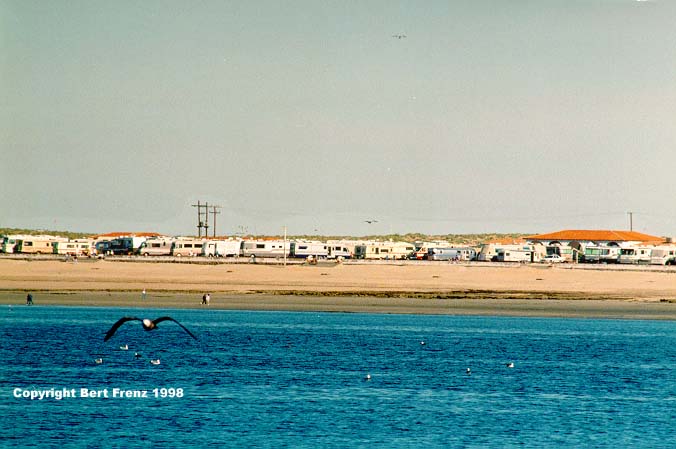 and learn that the beach sites are
all booked into the year 2000. However most parks, even those with beach access,
have openings for this evening and its only noon now. Many many people stay the whole
season year after year. We notice license plates from Iowa, Ohio, Saskatchewan, Arizona,
Washington, British Columbia and Oregon. There are more Americans here than Mexicans, I
think. Fees for the regular RV sites range in price from $13 per night to $18 with
discounts for weekly and monthly stays. At one of the parks I watch three men put
together one of those Port-a-botes and take it out into the ocean. I ask if they like the
boat and, more importantly, if it catches fish. They assure me it does and will bring me
some later this afternoon since they always catch a bucket full. I wish time permitted me
to take them up on the offer. We eat a wonderful lunch at Costa Bravo Restaurant,
and learn that the beach sites are
all booked into the year 2000. However most parks, even those with beach access,
have openings for this evening and its only noon now. Many many people stay the whole
season year after year. We notice license plates from Iowa, Ohio, Saskatchewan, Arizona,
Washington, British Columbia and Oregon. There are more Americans here than Mexicans, I
think. Fees for the regular RV sites range in price from $13 per night to $18 with
discounts for weekly and monthly stays. At one of the parks I watch three men put
together one of those Port-a-botes and take it out into the ocean. I ask if they like the
boat and, more importantly, if it catches fish. They assure me it does and will bring me
some later this afternoon since they always catch a bucket full. I wish time permitted me
to take them up on the offer. We eat a wonderful lunch at Costa Bravo Restaurant, 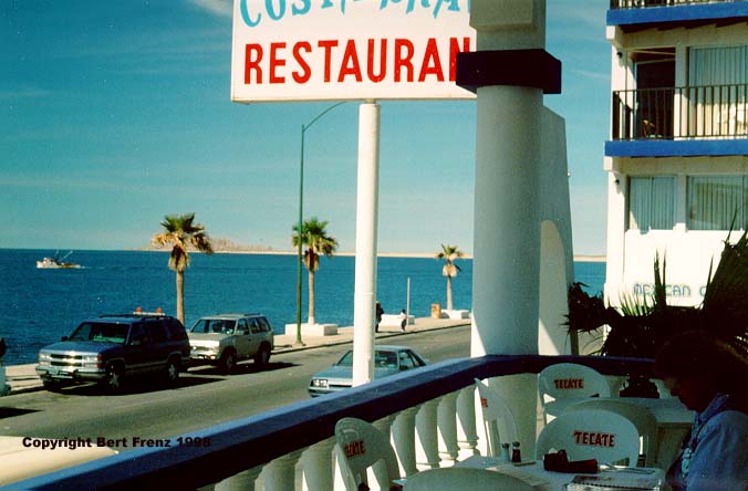 sitting on the terrace and watching porpoises,
seals and whales spouting in the sparkling water. Before leaving I stop at one of
the many fresh fish markets lining the street
sitting on the terrace and watching porpoises,
seals and whales spouting in the sparkling water. Before leaving I stop at one of
the many fresh fish markets lining the street 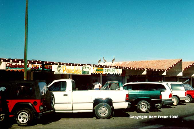 and purchase 3 lbs shrimp, 1-2
lbs flounder, 1-2 lbs pompano and 2-2 lbs redfish for the whopping low price of $20.
I would purchased more but what I already have will barely fit in the ice
chest that we have in the car. Puerto Penasco is an undiscovered beach side resort
and I plan to return next year with RTENT for an extended visit.
and purchase 3 lbs shrimp, 1-2
lbs flounder, 1-2 lbs pompano and 2-2 lbs redfish for the whopping low price of $20.
I would purchased more but what I already have will barely fit in the ice
chest that we have in the car. Puerto Penasco is an undiscovered beach side resort
and I plan to return next year with RTENT for an extended visit.
(BF). Although we stay camped at Organ Pipe, we travel by car today to Mexico. The
border crossing is only 5 miles from our campsite. After the border guard inspects a 5 ft
long canvas bag in our trunk (thinking guns?) he lets us pass when it turns out to be the
EZ-Up shelter we bought in Quartzsite. Our first Mexican view is of a desolate, dusty,
poverty stricken border town typical of the dozens we've visited before, always in
striking contrast to the comparative wealth only a few feet away on the U.S. side. But
quickly the town is behind us and the Sonoran Desert lies before us. To discerning eyes,
the Sonoran north of the border is strikingly different from that lying south and the
distinction is not geographic in nature. While the rainfall remains the same, the land
contours are unchanged and the soil is similar, the Mexican Sonoran Desert has been
stripped of its vivaciousness. It's a matter of history. When visited by an Italian friar
under charter of the Spanish crown 300 years ago, the Sonoran Desert was saddle high in
lush grasslands. With the introduction of cattle the landscape began to change. For
thousands of years the conservation mind set of the aborigine Tohono O'odham Indians
preserved the desert and their conversion to Catholicism and ranching produced few
environmental changes. But the miners returning from missing their fortunes in the
California Gold Rush, applied their enthusiasm to expanding the cattle business and as a
result of overgrazing, the grasslands diminished. By the 1930s park rangers visiting from
Yellowstone reported the onslaught of the Sonoran and to save the land, President
Roosevelt declared it a national monument in 1939. But it took until 1978 before the last
cattle were rounded up, following decades of arguments with established ranchers. In that
time the lushness of the desert has returned, but not the saddle high grasses. Such is not
the case for the Mexican side where grazing continues and the landscape lacks the beauty
of its northern neighbor.
We continue south for another 60 miles until we reach Rocky Point, the Anglicized name
for Puerto Penasco. The beauty of this sleepy fishing village at the top of the Gulf of
California is breathtaking. The local waters are called the Sea of Cortez, blue and calm
today, inviting as paradise. We traverse the well swept streets through the prosperous
town and stop at the fish market. While Shari visits the curio shops and fresh seafood
vendors I photograph the scenery and particularly the California and Heerman's Gulls which
allow close approach on the rocky shore behind the vendors' shacks. In the bay a trawler
is 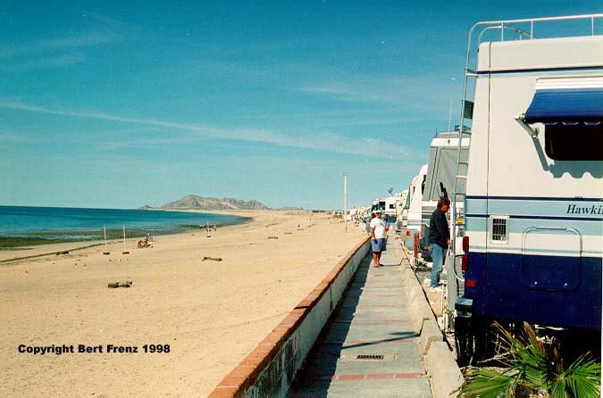 anchored and, lining the cables that
hold up the shrimp nets, I can see dozens of Brown Boobies through my binoculars. Sport
fishermen in smaller boats are reeling in a bountiful catch of Pompano, Redfish and
Trigger Fish. Brown Pelicans float on the bay, form crude circles and then beat their
wings furiously against the water to agitate the fish and bring them to the surface for
easy catching. As the bay curves past the village, the beach becomes more sandy and on its
northern extremity hundreds of RVs are parked. Continuing west, the sandy beach curves
southward and then rises to rocky cliffs jutting peninsular into the bay and providing the
derivation of Puerto Penasco.
anchored and, lining the cables that
hold up the shrimp nets, I can see dozens of Brown Boobies through my binoculars. Sport
fishermen in smaller boats are reeling in a bountiful catch of Pompano, Redfish and
Trigger Fish. Brown Pelicans float on the bay, form crude circles and then beat their
wings furiously against the water to agitate the fish and bring them to the surface for
easy catching. As the bay curves past the village, the beach becomes more sandy and on its
northern extremity hundreds of RVs are parked. Continuing west, the sandy beach curves
southward and then rises to rocky cliffs jutting peninsular into the bay and providing the
derivation of Puerto Penasco.
 Next
Day
Next
Day  Itinerary