Day 63 - Sunday, June 2 - Milepost 5789
- Birdcount 257 - Potter's Marsh, Alaska
 (BF's Journal). We leave Cooper’s Landing in
early morning and follow the coastline of Turnagain Arm most of the way north to
Anchorage. The tide is out, so the mud flats are exposed. After parking the Pace Arrow in
an unimpressive Anchorage RV site, we drive the Pathfinder back to Turnagain Arm in
anticipation of a Bore Tide, a six-foot wall of water bringing the high tide into the
narrow channel. Shari’s tide charts deceive us and six feet shrinks to six inches
barely visible with binoculars from our roadside perch at the bay’s edge.On the way
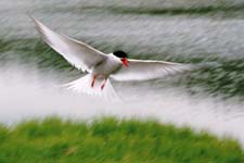
back, I pull off at Potter’s Marsh near another car to watch the nesting birds. As I
set up my telescope, two Arctic Terns attack me and I dive for cover. After three
or four attempts to view the marsh, I discover the terns have built a nest, or rather have
chosen a section
(BF's Journal). We leave Cooper’s Landing in
early morning and follow the coastline of Turnagain Arm most of the way north to
Anchorage. The tide is out, so the mud flats are exposed. After parking the Pace Arrow in
an unimpressive Anchorage RV site, we drive the Pathfinder back to Turnagain Arm in
anticipation of a Bore Tide, a six-foot wall of water bringing the high tide into the
narrow channel. Shari’s tide charts deceive us and six feet shrinks to six inches
barely visible with binoculars from our roadside perch at the bay’s edge.On the way
back, I pull off at Potter’s Marsh near another car to watch the nesting birds. As I
set up my telescope, two Arctic Terns attack me and I dive for cover. After three
or four attempts to view the marsh, I discover the terns have built a nest, or rather have
chosen a section 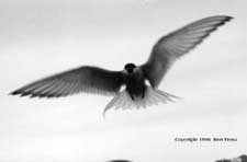 of barren gravel to lay a single egg and they view my proximity to the
"nest" as a threat. Ironically, the lady in the other automobile is not a threat
and she takes lots of close up photos. I try taking a few photos as the terns dive bomb
me. I'm using my 50mm lens since the tern is only a few feet from me. Finally I get too
close and the bomber swoops down on me as I throw my camera in front of my face to defend
myself. Click! I wonder if it's in focus?
of barren gravel to lay a single egg and they view my proximity to the
"nest" as a threat. Ironically, the lady in the other automobile is not a threat
and she takes lots of close up photos. I try taking a few photos as the terns dive bomb
me. I'm using my 50mm lens since the tern is only a few feet from me. Finally I get too
close and the bomber swoops down on me as I throw my camera in front of my face to defend
myself. Click! I wonder if it's in focus?
(SF's Journal). We reluctantly leave the
Kenai Peninsula headed for Anchorage and our RV appointment tomorrow. I do not feel
finished with this beautiful area and wish I could linger more, especially for some King
Salmon fishing. As we drive north I notice gates across the highway for avalanches
and periodically avalanche guns. Apparently avalanches are a danger in this section and
guns are detonated in the winter to force little avalanches before they become big.
The gates go down like gates across a railroad crossing and prevent traffic from
entering the danger zone. We park at John’s RV Park and Motel rated (5/8/6) but is
little more than a gravel parking lot in town. It is better than Ship Creek Landing
downtown which we could not find however. Missy asked what the ratings meant. On a scale
of one to ten the first number addresses completeness of facilities (store, dump, propane
etc.), the second number is for cleanliness and the third is for the visual environment.
We usually look at the third number since we have all the facilities we need in R TENT. We
arrive in Anchorage early so decide to head back out the way we came to view a bore tide.
I had never seen a bore tide and much of the information I had read describes it as
not to be missed. All I knew was that to see a bore tide we needed to be between
mile 27 and 32 (from Anchorage) 2Ľ hrs after low tide. So we head out to mile 27 and stop
at the pullout and look at the water. Pretty soon there are more cars stopped and looking
for the same thing we are. They ask, "Do you know what to look for?" Of course
we do not know, so we all continue peering at the water expecting a wall of water six feet
high to come at us like the parting of the Red Sea in the movie The Ten Commandments. One
couple from California pulls up and says "Here it comes. Right on time." Where?
Where? I wonder. "That white line," the woman retorts. Sure enough there is a
little wave about one feet high coming towards us at about one mile per hour. So that is a
bore tide. To be fair, the books do say that it can be one to six feet high but we did not
see it. Later, we watch television and find out about a forest fire not too far from
Anchorage that the fire marshall tentatively says is under control.
 Next
Day
Next
Day  Itinerary